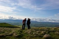
Walking
There are a number of very good walks in the area – in this section we’ll give you a few ideas. Walk from the doorstep by taking the much-enjoyed local walk to the village via the south drive and back via the road and the north drive – this is a brisk 35 minutes’walk. In both Chapel House and Tower House you will find a list of local walks, booklets with Perthshire walks, and we have a selection of Ordinance Survey maps that may be borrowed for walks further afield.
The Forestry Commission can offer many walks throughout Scotland. Check their site for information about the country’s forests and walks and what the Forestry Commission is doing to protect and expand them.
CNDo Scotland Guided walking holidays, self guided walking holidays, short walking breaks and outdoor skills courses. A 2005 winner of a Gold Award in the VisitScotland Green Tourism Business Scheme, which encourages tourism businesses to operate in an environmentally friendly way.
The Munros and Tops are for the serious walkers and ‘Munro baggers’ though some are perfectly achievable by the less expert. See the list of Munros along with grid references for each.
How about a walk across the Forth Road Bridge ? Make sure you have a head for heights! The 2.5km walk will give you great views inland toward the Ochil Hills and the distant Trossachs. To the East admire the world-famous Forth Rail Bridge.
Local Walks
At Duncrub you will be able to ‘walk the circuit’ leave from your door and walk via the South Drive to the village (10 minutes) and home via Station Road and the North Drive (or the other way round if you prefer) Either way it will take you around 40 minutes.
At Dalreoch we have created a river walk from the farm – park by the long sheds (there is a sign) and follow the arrows. You can sit by the river where seating has been provided. This is a very pleasant 25 minutes’ summer walk.
Historic Dunning
Distance: 4.5 miles
Difficulty: Moderate
Map: OS 58
Time: 2.5 hours
Start: Tron Square
The charming town of Dunning is the site of a Roman marching camp and a prehistoric fort. The village, which was burned by the Jacobites in 1715, also saw the burning of witches and was home to St Serf who, in the legend, killed the last dragon in Scotland.
From Tron Square by St Serf’s take the Muckart Road to Thorntree Square with its commemorative tree. On the far side go through the yard behind the garage to a footbridge over the burn. Pass through a kissing gate and cross the field to another. The path leads round a garden and along a road. Where the road bends left, go straight on by the last house. The burn narrows and the path is protected by railings. Just after this it bends left to join a road. (1/2 mile – 0.8 km)
Turn right up the road and shortly after the first gateway go through an archway in the stone wall. Follow the path that soon comes close to the burn again, running through woodland and over a side stream until it joins a larger track. Keep on the track and enter the glen. After walking beside the burn cross a footbridge. In 200 yards (180 metres) the track appears to ford the burn, take another bridge back. (1.5 miles – 2.4 lm)
On the right a small streams forms a waterfall. Continue to the end of the track and climb the steps on the left which rise to the top of the glen where there is a bench. On reaching the top go right for 200 yards (180 metres) until just before it bends left where a slight path leads down right to a viewpoint looking across to the Highlands. (2 miles – 3.2 km)
Proceed back down the glen via the upper path across a side stream through coppiced oak. After a right hand bend you can enjoy the view before descending the path to a steep bank. Take the path that zigzags down. (3 miles – 4.8 km)
At the bottom rejoin the track and turn right. The track bends right beside a field, turns stony and climbs a side valley. Emerge on to a minor road opposite a barn and turn left. As you enter Newton of Pitcairns the road makes two sharp bends then runs in a wide street between two houses. Halfway down, just beyond a white two-storey building, turn right up a path between two gardens. (4 miles – 6.4km)
The path leads between two tree-covered hillocks. Fork left and follow the small path up the back of the left hill. A short ascent takes you to the top of the Dunnock. Go along the top and through a gap in a stone wall to enjoy a superb view of Dunning. Descend leftwards, heading for the old school buildings, opposite which a gate gives access to the road. Turn right and walk downhill past old weaver’s cottages and back to Tron Square.
Craig Rossie
Distance: 5 miles
Height: 410m (1,345ft)
Difficulty: Steep — the scree can be dangerous
This climb challenges all walkers as Craig Rossie dominates the Strathearn scene from every angle. Especially enjoyable in August with the heather in bloom. Like all hill walking it requires great care and suitable clothing.
Go through the underpass at the foot of Ruthven Street or cross the bridge at Abbey Road. Turn left towards Dunning (B8062) as far as Pairney Farm on the right.
(Cars may be parked here but by permission only — observe the Country Code.)
For keen challenges head straight up, but with extreme care, particularly on the scree.
The more relaxes and scenic, if longer, route is by the gravel track through the quarry (home to rock ravens). Then south up the Pairney Burn Glen by a path through gorse and bracken, opening to a high pasture with heather and claeberry. Follow the track east, taking a left fork up to Bold Hill (this is now summit walking) to see the Pict Fort on Ben Effray to the north. Swing round to Craig Rossie, keeping to the high ground, and look back to see the three ring defences of the Pict Fort, (skirt with care a deep gully on your left) and reach the summit up a final grassy slope.
The Provost’s Walk, Auchterarder
Distance: 3 miles (approximately)
Difficulty: Easy
Name: In 1887 the Common Muir Commissioners of the town improved the path along the Lochy Burn to the Quarry calling it The Jubilee Walk. In 1932 it was extended to the Western Road and across the Golf Course to Tullibardine Road. To honour the Provost T E Young, it was renamed The Provost’s Walk.
Walk down Abbey Road past the millhands houses on the right to the Mills on your left to Ruthven Water. The Mills were the town’s main employers from the 1860’s until after World War II. (You can see the old power house.) (Another path off Abbey Road, before you pass Abbey Park, also leads to Ruthven Water : The Black Road or the Wee Roadie, once used by carts carrying coal from the station.)
Either way, turn right at the foot of the hill and following the Ladeside Walk beside Ruthven Water to Milton and the mill lade (i.e. water channel) where there was a meal mill and dye works. Beside the lade was the ford across the burn.
You are now on The Provost’s Walk, running parallel with the (barely visible but noisy) by-pass until the Walk turns right uphill. At the top of a rise on a clear day you can see Dunsinane, northwards near Coupar Angus (28 miles), beyond well wooded hills and fields. South are the Kincardine Castle woods, the home of the Grahams, where the great Marquis of Montrose lived as a boy. When the trees are bare you can see from here the ruins of trenches dug by Cromwell’s troop when they attacked the Castle (1650).
In a small dip by the Common Loan (a grassy track for animals) is the Coal Bore where, in the twentieth century, local men dug unsuccessfully for coal. The Bore became a popular swimming hole. Near it is the Granny Stane, an old Celtic standing stone.
Turn right, EITHER up Quarry Road or up Bogie Brae, passing right and left respectively of the play park and football field which lead to the Western Road. All this area is the old Common Muir, the staunchly defended property of the townsfolk.
Alternatively carry on down to the left following the path, keeping the fields and town cemetery on your right, to a small gate on to Western Road, just past Strathearn Home, the handsome old former Poor House.
You can either walk back to Townhead along Western Road or cross the road and through another small gate, follow The Provost’s Walk across Auchterarder Golf Course — bordering 5th hole fairway — and along the disused railway line to Orchil Road and Tullibardine Crescent. Turn right to Townhead.
(Please respect golfers’ rights — and golf balls!!)
Johnny Matthew’s Walk
Distance: Approximately 3 miles
Difficulty: Easy
Name: Johnnie Matthews (Mathies?) was a postman : this was his route.
Parking at Crown car park — on leaving turn right and into Ruthven Street. Go down to the bottom on Ruthven Street and, there by Ruthven Water, was Ba’ad’s Brae where the smiddy kept a roaring fire — very welcome on cold days. There was a popular sledging hill for children in winter and a swimming hole in summer.
Take tarmac path east of Turhven Water, through underpass, bear left and 25 yards on right is a path following the edge of Kincardine Estate — woodlands on the right, fields on the left. The path winds uphill to Woodend Farm where the main railway from London to the north is crossed by a stone bridge built wide enough for horsedrawn vehicles. Looking east from the bridge is an excellent view of Craig Rossie and Ben Affray with, to the left, an expanse of the Earn Valley.
Continuing, the path is narrowed by encroaching undergrowth. Leaving the wood behind at Buttend Cottage, with the farm above is another fine vista. Turn left and look on your right for the Victorian Gothic turrets of Cloan, home of Viscount Haldane philosopher and statesman, visited by every great man of the period from Lloyd George to Baden Pawell.
Continue past Lochie Farm and the old Auchterarder Railway Station to a Y fork. The left fork takes you past Bankhead Farm to the underpass. The right fork takes you over the motorway, Past Hally’s and Whilte’s Mills (see The Provost’s Walk) and then back uphill by Ruthenvale Terrace and Abbey Road to the High Street.
A much longer walk, turning right at Buttend Cottage is along Duchally Road — a please walk past Duchally House Hotel, with fine views. It takes you to the junction with Gleneagles (A823). Turn right, going over the motorway, past Gleneagles golf courses and Hotel to the Braco / Crieff roundabout — called Black Jock’s corner after the pre-war Police Sergeant who lived here. A right turn takes you back to town.
The Cadger’s Road
Distance: 8 miles (one way)
Difficulty: Moderate
Name: A ‘cadger’ is an itinerant peddler, a carter. This right of way follows an old route once used by cattle drovers bringing their cattle from the Highlands to the Falkirk Tryst.
The Ochils are a long range of steeply-sided, round topped hills which stretch 30miles from the banks of the Firth of Tay to Stirling.
Start the walk at Coulshill Farm. When you reach the road end continue up the right hand side of the glen on a farm track — this is signposted.
Approximately half a mile beyond Coulshill Farm pass the wooded area on the right and turn up left hand side of the tributary of the Coul Burn. Follow the track which leads away from it to cross the highest point on the route, in a shallow saddle between two small rounded peaks. From this point the path continued downhill through the Borland Glen to the youth hostel at the north end of Glendevon.
If you wish to extend the walk to the town of Dollar, turn left to Glendevon until you see a signpost on the right. Follow the pat across the River Devon to a small road on the far side of the glen. Turn right across a small bridge, and left again up a steep path into Glen Quey. The path is well defined and leads to Dollar.
(Approximately 4 miles)
Gleneagles Hotel – Blackford
Distance: 2¼ or 4½ miles (3.8 or 7.6 km)
Time: 1 or 2 hours
Terrain: Gravel paths across golf courses, then grassy track with mature woodland on one side and fields on the other.
Map: OS Landranger 58
Start/parking: Outside the Golf Academy in wide cul-de-sac opposite the main entrance to Gleneagles Hotel.
Grid ref: 921112
Before starting, admire the view opposite the Golf Academy across the Monarch’s golf course to Glen Eagles. From this angle you are looking almost directly up the steep sided glen. Then walk towards the gates of the Gleneagles Hotel and go left down the road for 50 yards. Cross the road and turn up a red gravel track that runs across the King’s golf course. You will see an array of signs indicating that this is part of a running circuit, a cycle way and a horse-riding route. Another asks you to keep dogs on a lead. Keep an eye out for stray balls and, although you shouldn’t be in the way of golfers, it’s always courteous to wait while any nearby play their strokes. After a flat stretch, with a view to the right of the hotel, the track climbs a gorse-covered bank. At the top it levels off and there is a fork to the right, which should be ignored. Keep straight on through a tall avenue of conifers.
Soon the track crests a knoll and bends to the left on the far side. In 100 yards you pass an incongruous ship’s bell. The bell, engraved ‘Stella 1875’ hangs on a wooden frame bearing the sign ‘Please ring after leaving the green’. It is used to let golfers approaching a blind green know that the preceding players have moved on. There is now another super panorama of the Ochils, with a more side-on view of Glen Eagles. Just beyond the bell the track bends right. Leave it and go straight on for a few yards then turn right on to a concrete buggy path. The path runs through a stand of larch then crosses a fairway to the back of the 7th tee. Here go left and immediately left again to drop down a hill to a double gate.
Go through the small metal gate and follow a grassy path downhill. There are now open fields on the left and a line of fine old beech and oak trees on the right. Look out for squirrels and soaring buzzards, which normally give away their presence with their mewing call. The open fields are popular in winter with feeding geese. The path crosses a stone slab over a burn that flows out of a couple of lochs. They are hidden in the woods to the right, but you may hear the sound of ducks and geese drifting down from them. Just beyond the burn there is a crossroads where a track from Drumlochy Farm on the left runs up into the woods.
Keep straight on, with an old stone wall on the left and the line of mature trees on the right. Now the land behind them is more open, rising uphill in a grassy slope. The walking is level and easy with fine views, but you may wish you could silence the nearby dual carriageway. As you come level with a tall stand of Scots pine go through a gate and continue down a smooth track where the grass is grazed short by rabbits. When you come to the fence round Comelyburn Farm head left to a small wooden gate. This takes you on to B8081 just beside a fenced council grit heap.
You can now turn round and enjoy the return walk to Gleneagles or continue into Blackford for refreshments or to catch the us back to the start. To reach Blackford turn right down the road and follow it into the centre of the village. The bus stops by the Blackford Hotel.
Walks further afield in Perthshire
Pitlochry – Edradour – Moulin
A walk of great variety, it combines a woodland walk past a waterfall and continues through farmland close to a ruined castle and returns through quiet town streets. It also passes two distilleries on the way.
Birnam Hill
This short but attractive walk is mainly in delightful deciduous woodlands. It passes around the eastern flank of Birnam Hill before climbing from the south. On the way a short detour leads to a magnificant view across fairytale-esqe landscapes to Rohallion Lodge. The walk then climbs up to the summit of Birnam Hill (404m) before dropping ever more steeply through more woodland back to the start.
Dunkeld – Loch Ordie – Deuchary Hill
A popular, mixed woodland and moorland wallk with four lochs in the hills above Dunkeld.
Dunkeld The Hermitage Strathbraan Dunkeld
This varied woodland walk first heads into Birnam village, visiting the Beatrix Potter Garden and the Birnam Oak, it then walks alongside part of the Rivers Tay and Braan, before leading to The Hermitage folly. It then leads up to and across Rumbling Bridge, in Strathbraan, before heading up and over to the Inchewan Burn which leads back down through woodland to the start.
Old Bridge of Tilt -Glen Tilt – Gows Bridge
Glen Tilt with its woodland, pasture, river and waterfalls, encased in high hills makes it one of Perthshire’s finest.
Pitlochry – Killiecrankie – Linn of Tummel
This walk has it all – a spectacular gorge, crags, huge dizzying bridges and viaducts, a loch, waterfalls, salmon ladders, luscious woodlands, ancient drove roads, monuments… There was even a battle here long ago! The walk passes through the Pass of Killiecrankie and Linn of Tummel, both areas of outstanding natural beauty.
Cleish Hills & Loch Glow
An interesting historical walk involving three hills (the highest at 379m), and four lochs.